Purpose of this web page: The pages linked to below focus primarily, but not exclusively, on (1) working forward from the earliest land grants of the property shown on the Peters Plan and the Salem Towne, Jr., map and (2) working backward from the land ownership of Acadia National Park by the United States government to the Peters Plan and Salem Towne, Jr., map. Another focus is tracing the deeds to land of the island’s cemeteries. The ultimate goal of this page is to include all land on Mount Desert Island.
How this page is organized: The first portion of this (very long) web page reports in chronological order the early land grants that lead to the Salem Towne Jr. map (western side of MDI) and the Peters Plan (eastern side), and contains links to the supporting deeds recorded in the Hancock County Registry of Deeds (Ellsworth, Maine). Bracketed material (e.g., [1:426]) refers to the book (1 in this example) and page(s) (426 in this example) of documents in the Hancock County Registry of Deeds. The second portion begins with an image of the Peters Plan on which horizontal bands have been drawn, and parcels falling (more or less) within each band have been numbered from west to east. Below the map is a table with basic information about each parcel. When deeds for a parcel are located, a link will be provided that will take you to a web page about that parcel. The third portion of this web page contains an image of the Salem Towne map and a table, following the pattern of the Peters Plan.
How you can help: Please send scanned images or photocopies of deeds to info@vfthomas.com or mail them to “MDI Deeds” at the address at the top of this page.
A little work by each of us will save a lot of work for all of us.
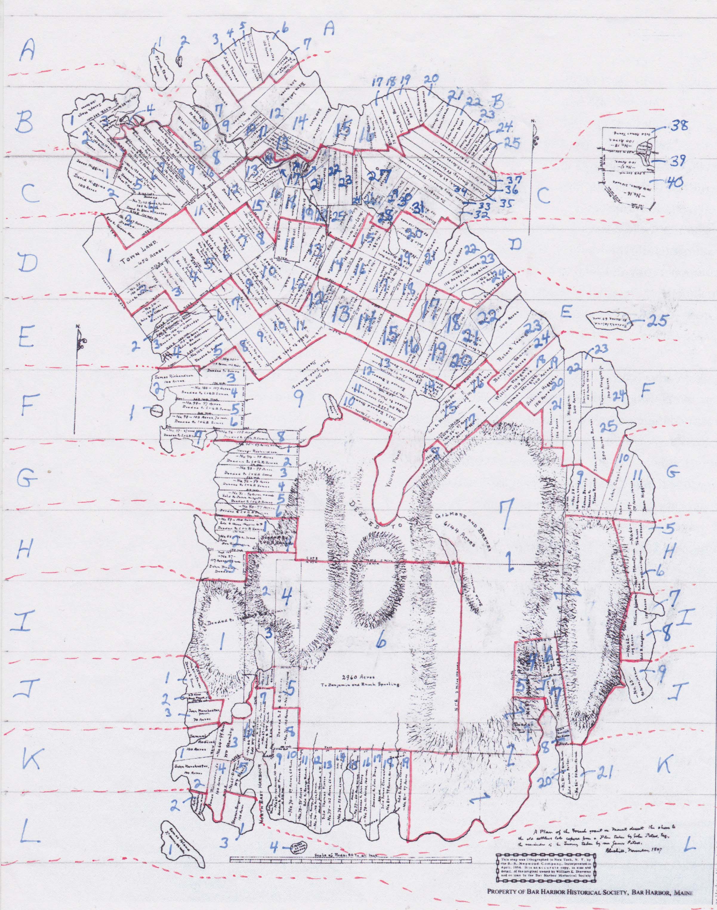
| Lot code from Peters Plan (above) | Lot size | Owner of Record per Peters Plan | Book:Page in Hancock County Registry of Deeds for earliest deed found |
Notes on Peters Plan |
| A1 | 30:313–314 | |||
| A2 | 30:313–314 | |||
| A3 | 100 acres | John Thomas | 6:257–258 | |
| A4 | 65 acres, 13 [square] rods by deed; 65 acres, 130 [square] rods by Peters Plan |
John Thomas | 6:258–259 | |
| A5 | 36 acres | Daniel Richardson | 27:12–13 | |
| A6 | 100 acres | Benjamin Hadley | 1:433–434 | |
| A7 | 54 acres, 65 [square] rods by deed; 54 acres, 25 [square] rods by Peters Plan |
Nehemiah Higgins | 12:361–362 | deeded |
| B1 | 100 acres | Joseph Mayo | 1:547–548 | |
| B2 | 150 acres, 128 [square] rods by land; 133 acres by plan |
Nahum Cousins | 66:270–271 | No. 9; sold Nahum Cousins; deeded |
| B3 | 89 acres | Israel Mayo, Moses H. Mayo | 151:91–92 | No. 10; sold to Israel Mayo & Moses H. Mayo |
| B4 | 22 acres | 183:371–372 | 22 acres marsh | |
| B5 | 100 acres | Eleazar Higgins | 1:430–431 | |
| B6 | 50 acres | DeGregoire | 621:347–348 | |
| B7 | 150 acres | Nicholas Thomas | 2:129–131 | |
| B8 | 118 acres | [N.?] Thomas | 72:8–10 | No. 11; sold to [N.?] Thomas, Esq. |
| B9 | 180 acres, 110 [square] rods | Nicholas Thomas Jr. | 19:152 | sold Nicholas Thomas Jr.; deeded |
| B10 | 30 acres | [?]. Thomas Jr. | 41:421–422 | sold [?]. Thomas Jr.; deeded |
| B11 | 60 acres | Thompson | 1:371–372 | Thomas Wasgatt Jr. to Thompson |
| B12 | 200 acres | Ezra Leland | 2:418–419 | |
| B13 | 98 acres by land including marsh & meadow; 139 acres, 80 [square] rods by plan |
41:123–124 | No. 12; deeded Thomas & Emery; sold Hull & Salisbury | |
| B14 | 200 acres | Ebenezer Leland | ???:??? | |
| B15 | 100 acres | Joseph Hopkins | 3:178–179 | |
| B16 | 100 acres | Ebenezer Salisbury | ||
| B17 | 75 acres, 106 [square] rods | Elkanah Young | 1:445–446 | |
| B18 | 50 acres | Timothy Baron | 2:134–135 | |
| B19 | 50 acres | Seth Doane | 217:187–189 | |
| B20 | 75 acres, 30 [square] rods | Daniel Hamor | ||
| B21 | 66 acres, 108 [square] rods | George Gillies | ||
| B22 | 55 acres, 90 [square] rods | John Hamor | ||
| B23 | 33 acres, 94 [square] rods | Henry Knowles | ||
| B24 | 24 acres, 114 [square] rods | Elkanah Young | 1:445–446 | |
| B25 | 39 acres, 28 [square] rods | Levi Higgins | 1:451–452 | |
| C1 | 100 acres | Jesse Higgins | 1:555 | |
| C2 | 100 acres | David Higgins | 1:554 | |
| C3 | 107 acres | Gideon Mayo | 66:434–435 | No. 8; deeded; sold to Gideon Mayo |
| C4 | 110 acres by land; 103 to plan | Eben M. Hadley | 85:2–3 | No. 7; deed to Eben M. Hadley |
| C5 | 122 acres by land; 98 acres, 100 [square] rods by plan |
Amos T. Hadley | 85:3–4 | deeded to Amos T. Hadley |
| C6 | 96 acres, 66 [square] rods | William B. Richards | 143:529–530 | No. 5; sold William B. Richards |
| C7 | 99 acres, 136 [square] rods | [Elliot Higgins or Alexander Higgins?] | 78:257–258 | No. 4; sold Elliot Higgins; deeded to Alexander Higgins |
| C8 | 96 acres | [Benjamin Thomas or Cornelius Thomas?] | 98:495–496 | No. 3; sold to Benjamin Thomas; deeded to Cornelius Thomas |
| C9 | 103 acres | [Ambrose Mayo or Solomon Higgins?] | 93:73–74 | No. 2; sold Ambrose Mayo; deeded Solomon Higgins |
| C10 | 40 acres | 51:388–389 | No. 1 | |
| C11 | 100 acres | N[...?] Richardson | 66:353–354 | No. 26; deeded |
| C12 | 100 acres | Daniel Richardson | 66:354–356 | No. 15; sold Daniel Richardson; deeded |
| C13 | 142 acres by land; of which 41 acres meadow & marsh |
Joel Emery | 61:248–249 | No. 14; sold to Joel Emery |
| C14 | 23 acres | This parcel is part of B13. | marsh and meadow | |
| C15 | Joel Emery | 61:114–115 | No. 17; sold to Joel Emery | |
| C16 | Joel Emery | 61:114–115 | No. 16; sold to Joel Emery | |
| C17 | [Eben Salisbury Jr. or Hopkins & Higgins?] | 65:196–197 | No. 13; deeded to Hopkins & Higgins | |
| C18 | 50 acres | Timothy Mason | 2:134–135 | |
| C19 | 50 acres | Seth Doane | 217:187–189 | |
| C20 | 28 acres | DeGregoire | ||
| C21 | 57 acres | Stephen Salisbury | 1:449–450 | |
| C22 | 53 acres | William Mason | 35:277–278 | |
| C23 | 67 acres | Henry Knowles | ||
| C24 | 61 acres | Levi Higgins | 1:451–452 | |
| C25 | 112 acres | Gideon Liscomb | No. 27; sold Gideon Liscomb; deeded | |
| C26 | 51 acres | John Davis [original deed was to John Hamor from DeGregoires] |
1:437–438 | John Davis farm |
| C27 | the greatest part heath | |||
| C28 | 45 acres | Black and Smallidge | ||
| C29 | DeGregoire | |||
| C30 | 34 acres | John Cousins | 2:419–420 | |
| C31 | 100 acres | Elisha Cousins | 1:446–448 | |
| C32 | DeGregoire | |||
| C33 | 95 acres, 60 [square] rods | widow Mary Hamor | 1:434–435 | |
| C34 | 69 acres, 140 [square] rods | Jonah Black | ||
| C35 | 88 acres, 31 [square] rods | Timothy Smallidge | ||
| C36 | 99 acres, 30 [square] rods | David Hamor | 1:438–440 | |
| C37 | 99 acres, 30 [square] rods | Elkanah Remick | 1:442–443 | |
| C38 | 100 acres | Abner Young | No. 18; sold Abner Young; [includes? 10 acres meadow] | |
| C39 | 100 acres | No. 17; [includes? 10 acres (meadow?)] | ||
| C40 | 144 acres, 24 [square] rods | No. 16 | ||
| D1 | 450 acres | town land | ||
| D2 | 100 acres | Prince Mayo | No. 25; sold to Prince Mayo | |
| D3 | 100 acres | I. and W. Hamor | 70:422–423 | No. 23 |
| D4 | 100 rods [sic] | James Mayo | 61:420–422 | No. 22; sold to James Mayo; includes part of heath |
| D5 | 100 acres | [David Higgins 2nd or David Higgins 3rd?] | 70:312–313 | No. 21; sold to David Higgins 3rd; deed to David Higgins 2nd; includes part of heath |
| D6 | 100 acres | Joel Mayo | 77:218–219 | No. 20; deeded; sold to Joel Mayo |
| D7 | 100 acres | Joel Emery | 61:248–249 | No. 19; sold to Joel Emery |
| D8 | 100 acres | Alan Young | 61:115–116 | No. 18; sold Alan Young; deeded |
| D9 | 108 acres, 120 [square] rods | John Haynes | 61:248–249 | No. E; sold to John Haynes; deeded |
| D10 | 284.5 acres | Joel Emery | 61:117–118 | No. D; deeded; sold Joel Emery |
| D11 | 100 acres | [Cornelius Thompson or Ebenezer?] | 8:534 | |
| D12 | 101 acres, 40 [square] rods | [Smith Hopkins or Joel Emery?] | No. 41; sold to Smith Hopkins; deeded to Joel Emery | |
| D13 | 119 acres, 128 [square] rods | [A. Leland or Joseph Stevens?] | 44:292–293 | No. 40; sold to A. Leland; deeded Joseph Stevens |
| D14 | 100 acres | William Peach | 70:459–460 | No. 39; deeded |
| D15 | 84 acres | Joel Emery | 61:248–249 | No. 28; sold Joel Emery |
| D16 | 100 acres | J.D. Jordan | 155:470 | No. 38; deeded to John G. Jordan |
| D17 | 100 acres | [Benjamin Bunker or John [G.?] Jordan?] | No. 37; sold Benjamin Bunker; deeded to John [G.?] Jordan | |
| D18 | 100 acres | Edward Brewer | 72:2–3 | No. 36; sold Edward Brewer |
| D19 | 102 acres, 114 [square] rods | E. Brewer | 72:2–3 | No. 30; sold E. Brewer |
| D20 | 93 acres, 120 [square] rods | E. Brewer | 72:2–3 | No. 29; sold E. Brewer |
| D21 | 120 acres | Solomon Rider | 1:452–454 | |
| D22 | 120 acres | Cornelius Thompson | 2:116–117 | |
| D23 | 115 acres, 116 [square] rods | Joshua Hopkins | 167:477–478 | No. 31; sold Joshua Hopkins |
| D24 | 99 acres | Edward Brewer | 72:2–3 | No. 32; sold Edward Brewer |
| E1 | 100 acres | B.W. Kittredge | 81:49–50 | No. 24; sold B.W. Kittredge |
| E2 | 100 acres by land; [by plan 37 ...?] | B. Richardson | No. 105; sold B. Richardson; deeded | |
| E3 | 102 acres | Dr. Kittredge | 83:44–45 | No. 104; deeded to Dr. Kittredge |
| E4 | 90 acres, as planned [includes? 15 acres, [?] [square] rods marsh] | Dr. Kittredge | 85:109–110 | No 103; sold to Dr. Kittredge; deeded |
| E5 | 96 acres, 60 [square] rods | [...] Somes | 124:490–491 | No. 102; deeded to Somes |
| E6 | 87 acres, 80 [square] rods | 61:248–249 | No. A; includes part of heath | |
| E7 | 105 acres | No. 13; deed; includes part of heath | ||
| E8 | 87 acres, 80 [square] rods | Joel Emery | 61:248–249 | No. H; sold to Joel Emery |
| E9 | 105 acres | Joel Emery | 61:248–249 | No. G; sold to Joel Emery |
| E10 | [108?] acres, 120 rods | Joel Emery | 61:248–249 | No. F; sold to Joel Emery |
| E11 | [Joel Emery or J[...?] ?] | 61:248–249 | No. E | |
| E12 | 100 acres | Joel Emery / Obadiah and Smith Hopkins | 61:248–249 | No. 42; sold to Obadiah and Smith Hopkins; sold Joel Emery |
| E13 | 100 acres | [B. Barker or John G. Jordan?] | No. 43; sold B. Barker; deeded to John G. Jordan | |
| E14 | [Samuel Hadley or John G. Jordan?] | No. 44; deeded John G. Jordan | ||
| E15 | 100 acres | Edward Brewer | 72:2–3 | No. 45; sold Edward Brewer |
| E16 | 95 acres | Edward Brewer | 72:2–3 | No. 46; sold Edward Brewer |
| E17 | 100 acres | Edward Brewer | 72:2–3 | No. 35; sold Edward Brewer |
| E18 | 98 acres, 82 [square] rods | Edward Brewer | 72:2–3 | No. 34; sold Edward Brewer |
| E19 | 99 acres | Edward Brewer | 72:2–3 | No. 47; sold Edward Brewer |
| E20 | 108 acres | Edward Brewer | 72:2–3 | No. 48; sold Edward Brewer; deeded |
| E21 | 75 acres | Edward Brewer | 72:2–3 | No. 33; sold to Edward Brewer |
| E22 | 240 acres | Ezra Young | 2:136–137 | |
| E23 | 100 acres | Robert Young | 1:389–390 | |
| E24 | 100 acres | Benjamin Stanwood | 1:388–389 | |
| E25 | 51 acres, 65 [square] rods | 16:204–205 | Rodick’s [now Bar] Island | |
| F1 | 124:490–491 | deeded | ||
| F2 | 100 acres | James Richardson | 3:293–294 | |
| F3 | 118 acres, 108 [square] rods | Somes | 124:490–491 | No. 101; deeded to Somes |
| F4 | 107 acres | I. and G.B. Some | 124:490–491 | No. 100; deeded to I. and G.B. Somes |
| F5 | 97 acres | I. and G.B. Somes | 124:490–491 | No. 99; deeded to I. and G.B. Somes |
| F6 | 102 acres, 70 [square] rods | I. and G.B. Somes | 124:490–491 | No. 98; deeded to I. and G.B. Somes |
| F7 | 67 acres, 66 [square] rods | I. and G.B. Somes | 124:490–491 | No. 97; deeded to I. and G.B. Somes |
| F8 | 102 acres, 30 [square] rods | I. and G.B. Somes | 124:490–491 | No. 96; deeded to I. and G.B. Somes |
| F9 | 700 acres | Jord. Emery | 61:248–249 | [Say?] 700 acres; sold Jord. Emery; deeded |
| F10 | 59 acres | Edward Brewer | 72:2–3 | No. 55; sold Edward Brewer |
| F11 | 107 acres, 40 [square] rods | Philip H. Hamor | 88:358–359 | No. 54; deeded to Philip H. Hamor |
| F12 | 108 acres, 10 [square] rods | Edward S. Brewer | 72:2–3 | No. 53 |
| F13 | 99 acres, 132 [square] rods | Edward Brewer | 58:488 | No. 52; deeded to Edward Brewer |
| F14 | 63 acres | Edward Brewer | 72:2–3 | No. 51; deeded; sold Edward Brewer |
| F15 | 119 acres | Stephen Higgins | 179:224–226 | No. 50; sold to Stephen Higgins |
| F16 | 111 acres, 88 [square] rods | 574:25–27 | No. 49 | |
| F17 | 87 acres | Oliver Higgins | 65:388–389 | No. 56; deeded to Oliver Higgins |
| F18 | 100 acres | William Wasgatt | 1:360–361 | |
| F19 | 100 acres | Thomas Wasgatt | 1:368–369 | |
| F20 | 100 acres | Solomon Higgins | 1:363–364 | |
| F21 | 100 acres | Humphrey Stanwood | 1:376–377 | |
| F22 | 200 acres | Israel Higgins | 2:555–556 | |
| F23 | 45 acres, 95 [square] rods | Daniel Rodick | 20:244‒245 | |
| F24 | 140 acres | Thomas Wasgatt Jr. | 1:371–372 | |
| F25 | 200 acres | John and Joseph Barker | 1:543–544 | [Thomas Wasgatt and Stephen Higgins purchased parcel from DeGregoires] |
| G1 | 47 acres, [80?] [square] rods | George Richardson | No. 95 | |
| G2 | 99 acres | I. and G.B. Somes | 124:490–491 | No. 94; deeded to I. and G.B. Somes |
| G3 | 99 acres | I. and G.B. Somes | 124:490–491 | No. 93; deeded to I. and G.B. Somes |
| G4 | 99 acres | I. and G.B. Somes | 124:490–491 | No. 92; deeded to I. and G.B. Somes |
| G5 | 96 acres, 40 [square] rods | [Jason Wasgatt or I. and G.B. Somes?] | 124:490–491 | No. 91; sold to Jason Wasgatt; deeded to I. and G.B. Somes |
| G6 | 94 acres | I. and G.B. Somes | 124:490–491 | No. 90; deeded to I. and G.B. Somes |
| G7 | 6144 acres | Gilmore and Brewer | 81:211–213 | deeded to Gilmore and Brewer |
| G8 | 60 acres | 183:51–53 | No. 57 | |
| G9 | 166 acres, 48 [square] rods | [James Beverly or Tobias Roberts?] | 75:170–171 | No. 58; deeded to Tobias Roberts |
| G10 | 100 acres | John Cousins | 2:558–559 | |
| G11 | 175 acres, 116 [square] rods | Dean Higgins | No. 59; sold | |
| H1 | 100 acres | [Oliver Higgins 4th or I. and G.B. Somes?] | No. 89; sold to Oliver Higgins 4th; deeded to I. and G.B. Somes | |
| H2 | 116 acres, 70 [square] rods | Benjamin Richardson | 169:57–59 | No. 88; sold Benjamin Richardson |
| H3 | 117 acres, 92 [square] rods | John Brown | 78:58–59 | No. 87; deeded |
| H4 | I. and G.B. Somes | deeded to I. and G.B. Somes | ||
| H5 | 96 acres, 144 [square] rods | 174:100–102 | No. 60 | |
| H6 | 99 acres, 72 [square] rods | Henry and Oliver Higgins | 474:475–479 | No. 61; sold |
| I1 | Isaiah and G.B. Somes | deeded to Isaiah and G.B. Somes | ||
| I2 | 60 acres | Isaiah and G.B. Somes | No. 63; deeded to Isaiah and G.B. Somes | |
| I3 | 124:490–491 | |||
| I4 | Isaiah and G.B. Somes | |||
| I5 | 100 acres | Isaiah and G.B. Somes | No. 72; deeded to Isaiah and G.B. Somes | |
| I6 | 2960 acres | Benjamin and Enoch Spurling | 69:49 | |
| I7 | 100 acres | William Lynam | 510:486–487 | |
| I8 | 109 acres | B. Hodgdon | 151:97–98 | No. 62; sold B. Hodgdon |
| J1 | 65 acres, 40 [square] rods | Somes | No. 84; deeded to Somes | |
| J2 | 23 acres | Davis Wasgatt Jr. | 30:138–139 | deeded |
| J3 | 70 acres | John Manchester Jr. | 1:410–411 | |
| J4 | 77:559 | No. 85; deeded | ||
| J5 | 143:476–477 | No. 86 | ||
| J6 | 75 acres | Timothy Smallidge | 100:385–386 | No. 84; deeded; sold |
| J7 | 90 acres, 96 [square] rods | Samuel Hadley | 143:188–189 | No. 83; sold |
| J8 | Ed. Brewer | 124:122–123 | deeded to Ed. Brewer | |
| J9 | 90 acres, 148 [square] rods | 471:400–401 | No. 63 | |
| K1 | 100 acres | Samuel Hadlock | 1:412–413 | |
| K2 | 100 acres | John Manchester | 1:448–449 | |
| K3 | 99 acres | William Stanley | No. 64 | |
| K4 | 100 acres | James Richardson Jr. | 1:369–370 | |
| K5 | 81 acres, 76 [square] rods | William Stanley | No. 65 | |
| K6 | 93 acres | William Roberts Jr. | 85:219–220 | No. 66; sold William Roberts Jr. |
| K7 | 105 acres, 140 [square] rods | William Roberts Jr. and John Savage | 85:163–164 | No. 67; sold William Roberts Jr. and John Savage; deeded to William Roberts [Jr.?] |
| K8 | 100 acres | Isaiah and G.B. Somes | 124:490–491 | No. 71; deeded to Isaiah and G.B. Somes |
| K9 | 100 acres, 115 [square] rods | [Thomas Pung or Harriett Pung?] | 70:515–516 | No. 69; sold Thomas Pung; deeded to Harriett Pung |
| K10 | 89 acres, 60 [square] rods | 176:425–426 | No. 70 | |
| K11 | 95 acres | [George Roberts or Thomas Savage?] | 92:314–315 | No. 73; sold to George Roberts; deeded to Thomas Savage |
| K12 | 102 acres, 30 [square] rods | [John Savage Jr. or James Clement 2nd?] | 95:398–399 | No. 74; sold John Savage Jr; deeded James Clement 2nd |
| K13 | 102 acres, 68 [square] rods | Thomas Pierce | 216:403–406 | No. 75; sold Thomas Pierce |
| K14 | 83 acres, 26 [square] rods | John Pung | No. 76; sold to John Pung | |
| K15 | 64 acres, 40 [square] rods | Southard | 106:204–205 | No. 77; sold to Southard; deeded |
| K16 | 101 acres, 140 rods | John Bracy | 68:59–60 | No. 78; deeded to John Bracy |
| K17 | John Bracy | 68:59–60 | deeded to John Bracy | |
| K18 | 99 acres, 160 rods | James Clement | 66:315–316 | No. 80; sold James Clement |
| K19 | 97 acres | James Clement | 66:315–316 | No. 81 [sic]; sold to James Clement |
| K20 | 65 acres, 36 [square] rods | Luther Parker | 132:305 | No. 81 [sic] |
| K21 | 50 acres, 132 [square] rods | 625:510–511 | No. 86 | |
| L1 | 77 acres, 46 [square] rods | 1:423 | Somes’ Island [now Greening Island] | |
| L2 | 30 acres, 10 [square] rods | John Manchester Jr. | 1:410–411 | |
| L3 | 100 acres | Stephen Sargent | 1:440–441 | |
| L4 | 9 acres, 62 [square] rods | 72:51–52 | deeded |
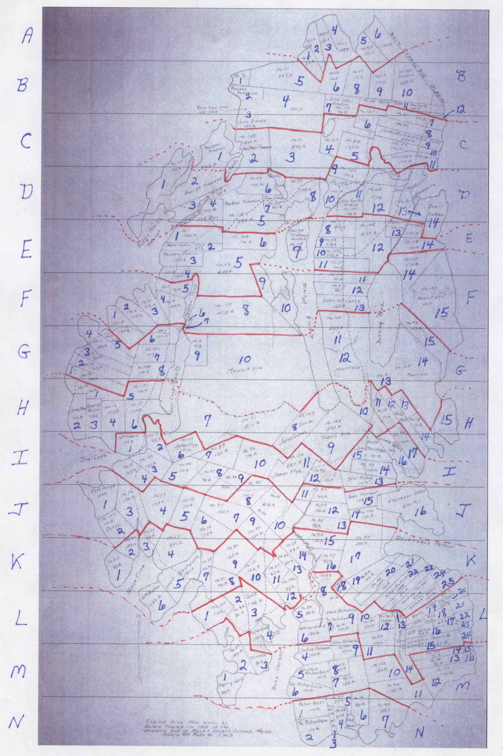
| Lot code from Salem Towne map (above) | Lot size | Owner of Record per Salem Towne map | Book:Page in Hancock County Registry of Deeds for earliest deed found |
Notes |
| A1 | 56 acres | 48:115–116 | No. 70; Bar Harbor | |
| A2 | 63 acres | 33:103 | No. 69; Bar Harbor | |
| A3 | 58 acres | No. 62; Bar Harbor | ||
| A4 | 128 acres | 56:484–483 | No. 67; Bar Harbor | |
| A5 | 100 acres | No. 64; Bar Harbor | ||
| A6 | 100 acres | Bar Harbor | ||
| B1 | No. 70; Bar Harbor | |||
| B2 | Reuben Freeman | |||
| B3 | 150 acres | John Smith | ||
| B4 | 300 acres | |||
| B5 | 227 acres | 61:394 | No. 71; Bar Harbor | |
| B6 | 100 acres | 30:327 | No. 66; Bar Harbor | |
| B7 | 96 acres | John Lear | No. 119; sold | |
| B8 | 110 acres | 48:201–202 | No. 65; Bar Harbor | |
| B9 | 110 acres | No. 63; Bar Harbor | ||
| B10 | 206 acres | No. 144; sold; Bar Harbor | ||
| B11 | 100 acres | Peter Page | 11:458–459 | No. 120; sold |
| B12 | ||||
| C1 | part of 362 acres | Reuben Freeman | ||
| C2 | 200 acres | Reuben Freeman | No. 126 | |
| C3 | 370 acres | 66:1 | No. 111 | |
| C4 | 139 acres | 39:500–501 | No. 123 | |
| C5 | 125 acres | No. 62 | ||
| C6 | No. 121 | |||
| C7 | 100 acres | 32:80–81 | No. 61 | |
| C8 | No. 60 | |||
| C9 | 200 acres | heirs of James Richardson | ||
| C10 | 100 acres | No. 59 | ||
| C11 | 100 acres | Abraham Somes | ||
| D1 | 185 acres | 33:308–309 | No. 75 | |
| D2 | part of 362 acres | George Freeman | ||
| D3 | 115 acres | No. 74 | ||
| D4 | 102 acres | Ephraim Pray | ||
| D5 | 288 acres | Reuben Freeman | No. 127 | |
| D6 | 105 acres | No. 73 | ||
| D7 | 60 acres | town land | No. 145 | |
| D8 | 138 acres | No. 110 | ||
| D9 | 100 acres | 66:329–330 | No. 125 | |
| D10 | 100 acres | No. 143 | ||
| D11 | 100 acres | John Gulley [sic] | No. 130; sold | |
| D12 | 157 acres | No. 109 | ||
| D13 | 196 acres | Samuel Reed | ||
| D14 | Daniel Somes | |||
| E1 | 126 acres | 31:32–33 | No. 1 | |
| E2 | 67 acres | heirs of David Eaton | 48:112–113 | |
| E3 | 100 acres | Reuben Noble | ||
| E4 | 70 acres | No. 2 | ||
| E5 | 449 acres | No. 113 | ||
| E6 | 106 acres | No. 129 | ||
| E7 | 104 acres | George Freeman | No. 128; sold | |
| E8 | 97 acres | No. 57 | ||
| E9 | 57.5 acres | No. 56 | ||
| E10 | 57.5 acres | No. 571/2 | ||
| E11 | 100 acres | No. 56 | ||
| E12 | 228 acres | No. 108 | ||
| E13 | 100 acres | Daniel Somes | No. 121 | |
| E14 | 100 acres | No. 58 | ||
| F1 | 128 acres | No. 9 | ||
| F2 | 105 acres | No. 6 | ||
| F3 | 102 acres | No. 5 | ||
| F4 | 103 acres | No. 4 | ||
| F5 | 70 acres | No. 3 | ||
| F6 | ||||
| F7 | ||||
| F8 | 462 acres | No. 114 | ||
| F9 | ||||
| F10 | ||||
| F11 | 100 acres | No. 54 | ||
| F12 | 96 acres | 54:564 | No. 53 | |
| F13 | 120 acres | Davis Wasgatt | 30:326–327 | |
| F14 | 170 acres | 34:385–386 | No. 107 | |
| F15 | No. 147 | |||
| G1 | 100 acres | 36:209–210 | No. 14 | |
| G2 | 103 acres | No. 13 | ||
| G3 | 80 acres | 60:568–569 | No. 12 | |
| G4 | 146 acres | No. 11 | ||
| G5 | 50 acres | No. 10 | ||
| G6 | 100 acres | No. 7 | ||
| G7 | 107 acres | No. 150 | ||
| G8 | 100 acres | No. 149 | ||
| G9 | 91 acres | No. 8 | ||
| G10 | ||||
| G11 | 224 acres | |||
| G12 | ||||
| G13 | 130 acres | |||
| G14 | No. 105 | |||
| G15 | 153 acres | No. 52 | ||
| H1 | 100 acres | No. 15 | ||
| H2 | 102 acres | James Reed | ||
| H3 | 92 acres | George Butler | ||
| H4 | 140 acres | No. 16 | ||
| H5 | 100 acres | No. 151 | ||
| H6 | 120 acres | No. 17 | ||
| H7 | 510 acres | No. 91 | ||
| H8 | 200 acres | Jacob Somes | No. 133 | |
| H9 | 360 acres | town’s use | No. 146 | |
| H10 | ||||
| H11 | 77 acres | No. 49 | ||
| H12 | 96 acres | No. 50 | ||
| H13 | ||||
| H14 | 71 acres | No. 115 | ||
| H15 | ||||
| I1 | 100 acres | William Heath | ||
| I2 | 95 acres | Ezra H. Dodge | 42:495–496 | No. 18 |
| I3 | 121 acres | No. 138 | ||
| I4 | 108 acres | No. 19 | ||
| I5 | 100 acres | No. 88 | ||
| I6 | 100 acres | James Flye | 42:494–495 | No. 137 |
| I7 | 120 acres | No. 89 | ||
| I8 | 90 acres | No. 87 | ||
| I9 | 93 acres | No. 86 | ||
| I10 | 170 acres | No. 90 | ||
| I11 | 220 acres | James Flye | No. 136 | |
| I12 | 100 acres | 31:531–532 | No. 92 | |
| I13 | 100 acres | [Benjamin] Tyler Reed | 28:212–213 | unnumbered |
| I14 | 100 acres | No. 47 | ||
| I15 | 110 acres | John Manchester | No. 135 | |
| I16 | 100 acres | William Gilley | 53:195 | unnumbered |
| I17 | 100 acres | No. 48 | ||
| J1 | 150 acres | Ezra Dodge | ||
| J2 | 100 acres | Ezra H. Dodge | 39:547–548 | No. 139 |
| J3 | 156 acres | No. 76 | ||
| J4 | 163 acres | No. 77 | ||
| J5 | 100 acres | No. 78 | ||
| J6 | 132 acres | No. 79 | ||
| J7 | 140 acres | No. 84 | ||
| J8 | 100 acres | No. 85 | ||
| J9 | 120 acres | No. 83 | ||
| J10 | 212 acres | Nos. 30 and 31 | ||
| J11 | 100 acres | No. 93 | ||
| J12 | 100 acres | No. 94 | ||
| J13 | 98 acres | No. 95 | ||
| J14 | 100 acres | No. 46 | ||
| J15 | 102 acres [on map]; 100 acres [in deed] |
George Harmon | 6:396 | |
| J16 | 270 acres | Ebenezer Eaton | ||
| K1 | 95 acres | No. 22 | ||
| K2 | 58 acres | No. 20 | ||
| K3 | 74 acres | No. 21 | ||
| K4 | 200 acres | No. 23 | ||
| K5 | 160 acres | Enoch Wentworth | ||
| K6 | 125 acres | William Nutter | ||
| K7 | 106 acres | No. 24 | ||
| K8 | 72 acres | No. 81 | ||
| K9 | 125 acres | No. 80 | ||
| K10 | 162 acres | No. 151 | ||
| K11 | 67 acres | No. 27 | ||
| K12 | 92 acres | No. 142 | ||
| K13 | 60 acres | No. 22 | ||
| K14 | 68 acres | No. 29 | ||
| K15 | 100 acres | No. 96 | ||
| K16 | 92 acres | No. 97 | ||
| K17 | 300 acres | No. 45 | ||
| K18 | 33 acres | Langley and Moore | ||
| K19 | 100 acres | No. 44 | ||
| K20 | 100 acres | No. 43 | ||
| K21 | 100 acres | |||
| K22 | 100 acres | Peter Dolliver | ||
| K23 | 90 acres | |||
| K24 | 100 acres | Andrew Tucker | ||
| K25 | 100 acres | Samuel Bond | ||
| L1 | 112 acres | No. 25 | ||
| L2 | 80 acres | No. 82 | ||
| L3 | 142 acres | — Gott | ||
| L4 | 100 acres | — Richardson | ||
| L5 | 58 acres | No. 32 | ||
| L6 | 100 acres | William Norwood | ||
| L7 | ||||
| L8 | 80 acres | No. 98 | ||
| L9 | 100 acres | Enoch Richardson | No. 41; sold | |
| L10 | 50 acres | No. 40 | ||
| L11 | 140 acres | No. 99 | ||
| L12 | Richard Tucker | |||
| L13 | 10 acres | No. 41 | ||
| L14 | 120 acres | John S. Grow | ||
| L15 | 167 acres | Longley, Moore, and Longley | ||
| L16 | 80 acres | William Grow | ||
| L17 | 63 acres | |||
| L18 | 100 acres | Joshua Ray | ||
| L19 | 100 acres | Benjamin Ward | ||
| L20 | 13 acres | No. 72 | ||
| L21 | ||||
| L22 | ||||
| L23 | ||||
| L24 | ||||
| M1 | 100 acres | Merry heirs | 1:417 | unnumbered |
| M2 | 140 acres | No. 26 | ||
| M3 | 8 acres | — Benson | ||
| M4 | 100 acres | — Norwood | ||
| M5 | 100 acres | Abraham Richardson | 10:410–412 | unnumbered |
| M6 | 100 acres | Thomas Richardson | ||
| M7 | 126 acres | No. 101 | ||
| M8 | 48 acres | No. 33 | ||
| M9 | 94 acres | Abraham Richardson | No. 143 | |
| M10 | 120 acres | No. 103 | ||
| M11 | 167 acres | No. 102 | ||
| M12 | 140 acres | No. 37 | ||
| M13 | 80 acres | No. 38 | ||
| M14 | 70 acres | No. 39 | ||
| M15 | ||||
| M16 | ||||
| N1 | 100 acres | Peter Gott | ||
| N2 | 110 acres | Thomas Richardson | ||
| N3 | 19 acres | No. 116 | ||
| N4 | 64 acres | No. 35 | ||
| N5 | 52 acres | No. 34 | ||
| N6 | 86 acres | No. 36 | ||
| N7 | 198 acres | No. 103 |