Location. On private land off Carter Road. UTM: 19T 0545787, 4906497; Lat./Long.: N 44°18′37.0″ x W 68°25′33.2
Directions. From the intersection of Routes 3 and 102/198 at the north end of Mount Desert Island, go straight ahead (south) onto Routes 102/198. In approximately 5.2 miles (and at the south end of the village of Somesville), turn right onto Pretty Marsh Road (Route 102). Travel on Route 102 about 5.1–5.2 miles to the intersection with Cape Road on the right. Turn right onto Cape Road, and in approximately 1.2–1.3 miles, the Carter Road is on the right. Follow the Carter Road to a fork in about 0.1–0.2 miles. The right fork leads to the property containing the graves, which are downhill from a red barn.
History. This cemetery is on land that was part of lot #11, a 146 acre parcel, on the 1808 Salem Towne Jr. map.
Notes. These stones are completely overgrown by shrubs and small trees. Recording the inscription required crawling on hands and knees. Though still overgrown, the stones are now enclosed by a low, picket fence.
Names and dates on gravestones and other markers. (complete as of 26 July 2011)
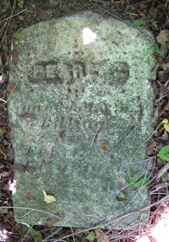
BILLINGS
Pearl J. (son of J. M. and [V. or M.?]1 A. [no stones]) - d. 1 February 1878 Æ 1[5?]1 y., 10 m. (gravestone)
[…]
[…]2
Notes:
1Difficult to read.
2Only the base of a stone was found. It is not the base of the Pearl J. BILLINGS stone because the holes in this base and the holes in the BILLINGS stone do not line up. A photograph in the collection of Ray Robbins indicates that this may belong to Mary [wife of John BILLINGS] - d. 20 J[…]1 187[1?]1.